Several streets in Ridgewood could be getting major safety improvements thanks to outreach from the Greater Ridgewood Youth Council (GRYC).
Members of Community Board 5’s (CB 5) Transportation and Public Transit Committees considered at their Feb. 28 meeting suggestions from the GRYC on ways to make the roads safer across the neighborhood, with a focus on repainting crosswalks and other markings at intersections, conducting stop sign studies, and the instillation of stop lines at several intersections.
According to the GRYC presentation, the 104th Precinct reported that there were 156 pedestrian injuries within CB 5 in 2016.
“Our goal is to help reduce the number of pedestrian injuries and fatalities on our community by: generating awareness of dangerous conditions for pedestrians in some of Ridgewood’s most trafficked areas, [and] encouraging the appropriate agencies to take action to improve the conditions at these intersections,” the presentation read.
After looking at the statistics provided by the GRYC — which was gathered through the NYC Department of Transportation (DOT) Vision Zero plan; the Fulcrum mobile app, which is a database for entering and tracking observations at intersections; and community input — the CB committees made a list of six intersections where they would like to see specific changes, and will officially request these changes be made by DOT.
The requests CB 5 will make to DOT include:
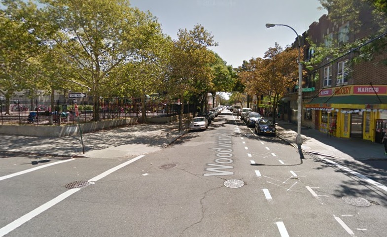
- Woodward Avenue and Woodbine Street
- Conduct a stop sign study for speeding cars on Woodward Avenue at Woodbine Street
- Fairview Avenue and Putnam Avenue
- Remark of crosswalk markings on Fairview Avenue
- ADA curb treatment on the northeast corner of the intersection
- Instilla of stop line on Putnam Avenue
- Striping of crosswalks on Putnam Avenue
- Forest Avenue and Putnam Avenue
- Install crosswalks on Putnam and Forest avenues
- Install walk signals
- Wyckoff Avenue and Cooper Avenue
- Install stop lines
- Install Leading Pedestrian Interval (LPI) in both directions
- Restripe markings
- Install lighting
- Myrtle Avenue at Summerfield Street and 60th Lane
- Install stoplight or pedestrian signal at Myrtle Avenue and Summerfield Street
- Install crosswalk on Myrtle Avenue and 60th Lane
- Eliminate parking from bus stop on Myrtle Avenue and 60th Lane to corner of Decatur Street and Myrtle Avenue
- Cypress Hills Street, Central Avenue and Otto Road
- Reduce permitted vehicular movements (there are currently 20 allowed)
- Install walk signals for pedestrian traffic crossing Otto Road
- Install LPIs
- Refurbish markings at the intersection
Where the GRYC suggests LPIs, the addition of crosswalks, ADA curbs, stop signs and signal changes, CB 5 requests that DOT study those areas if they have not been requested for study in the last five years. Additionally, the committees insist that any parking elimination that DOT sees as increasing safety should be reported back to them.
“Finally, we request DOT examine the conditions at Forest and Putnam (in conjunction with suggestions from the GRYC for Fairview and Putnam avenues) with regard to the double parking occurring along the north side of the Greenstreets triangle, which often conflicts with the use of that segment of Putnam as a bus layover,” the committees wrote in a notice to DOT. “Bollards or other devices should be considered to discourage parking in this area.”