By Chris Engelhardt
The city Department of Transportation announced it is beginning to install new pedestrian maps to help New Yorkers find their way around the city’s streets in Manhattan and other areas, including Long Island City.
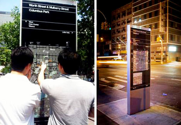
DOT Commissioner Janette Sadik-Khan said Tuesday the agency’s sign system, called Walk NYC, is the first step toward a citywide pedestrian information system that will provide New Yorkers and visitors with critical navigating information making it fast, simple and convenient to get around.
The signs installed directly into sidewalks and in subway stations will feature clear, readable maps showing area streets, major points of interest, travel information such as bike lanes and subway stations and an estimated walking times for pedestrians.
The DOT said four initial signs will be installed at key intersections in Chinatown, and the system will expand to 34th Street and the Garment District in Midtown, Prospect Heights and Crown Heights in Brooklyn and Long Island City in August. DOT also plans to install signs in Manhattan below Houston Street this fall.
The first phase of the program will include roughly 100 free-standing signs measuring 18, 34 or 50 inches wide and approximately 8.5 feet tall. Each design features a “heads-up” map oriented in the direction the viewer is facing, providing a clearer guide to nearby destinations.
The design also displays compass directions, neighborhood destinations and nearby transit connections for easy reference. The design is the result of a 2011 RFP and the selection of a design by PentaCity Group, a collaboration among wayfinding specialists City ID, industrial designers Billings Jackson Design, graphic designers Pentagram, GIS database developers and cartographers, T-Kartor, with engineering and urban design by RBA Group.
The DOT conducted more than 500 surveys around the city to determine both residents’ and visitors’ knowledge of local areas and confidence navigating on foot. Roughly 13 percent of residents were not familiar with the area where they were surveyed,while 14 percent of residents and 27 percent of visitors, were unable to name the neighborhood or borough they were in at the time.
The system was approved by the city Public Design Commission and the city Landmarks Preservation Commission, the DOT said. The WalkNYC program was developed largely with federal grants and DOT’s partners brought funding to the program for fabrication and installation within their areas.
Elected officials and Queens community leaders, including Councilman Jimmy Van Bramer (D-Sunnyside), said they believe the system will be effective and provide direct information to residents and tourists.
“As Long Island City is integrated into the launch of this wonderful system, we will be able to highlight one of New York City’s hottest neighborhoods for all to see,” he said. “With some of the city’s best cultural institutions and arts organizations, Western Queens offers a wide array of venues that will once and for all put Long Island City on the map for good.”
Reach reporter Chris Engelhardt by e-mail at cengelhardt@cnglocal.com or by phone at 718-260-4564.