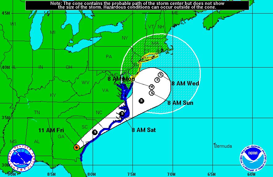
The first major tropical storm to hit the United States this year is crawling up the Eastern Seaboard, and Queens can expect to feel its effects beginning this Labor Day weekend.
Friday morning, the National Weather Service (NWS) issued a tropical storm watch for the five boroughs of New York City through next Friday, Sept. 9. Hermine is expected to travel very slowly up the East Coast into early next week. Its center is forecast to sit off the Delmarva Peninsula at Sunday morning, but will stall and churn off the coast of Long Island through Wednesday morning. It is expected to strengthen briefly into a hurricane before reverting into a tropical storm.
“That’s an unusual situation for such a large storm to stall and remain in place and have a direct impact on the city for such a long period of time,” Mayor Bill de Blasio said at a press conference on Friday morning. “That’s one of the things that’s causing us some real concern.”
The immediate concern for the moment is rip tides, which de Blasio — citing NWS forecasters — said could be some of the strongest seen in the area in more than a decade. As a result, the city has ordered all beaches closed for swimming on Sunday.
Going into next week, as Hermine gets closer to the city, there is the potential for high winds and significant coastal flooding in areas such as Howard Beach, Broad Channel and the Rockaways. De Blasio did not rule out possible evacuations of flood zones and the potential closure of bridges if conditions warrant them.
“All New Yorkers need to be vigilant all the way until Wednesday,” de Blasio said, “because this storm is going to be hanging around for a while.”
Tropical Storm Hermine struck northern Florida early Friday morning as a hurricane, but was downgraded after traveling over land into Georgia. It’s currently pounding the southeast U.S. with heavy rain, high surf in the coastal areas and winds of up to 70 mph.
The storm is not expected to make landfall in our area, but the NWS indicates that the New York City area will likely experience coastal flooding, strong rip currents, gale force winds and periods of heavy rain starting on or about early Sunday morning.
The city is mobilizing now for the potential effects of Hermine. The city’s Department of Emergency Management (EM) is in close contact with the NWS and the National Hurricane Center along with various city agencies regarding storm preparations. The Buildings Department ordered a ban on all outdoor work beginning at 3 p.m. Saturday and continuing until further notice.
Residents in areas prone to coastal flooding such as the Rockaways, Broad Channel and Howard Beach should have sandbags, plywood, plastic sheeting and other materials on hand to protect their homes from flood damage. Click here to see if your home is in a flood zone.
Everyone should have a “Go Bag” full of essential items and supplies that they can take with them in the event they need to leave their homes immediately.
Visit the city’s Emergency Management website for further information about storm preparedness.