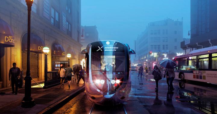
The proposed street car to connect the Brooklyn and Queens waterfront has been highly debated for the last few months, and on Monday, the city released a study outlining some specifics.
Nonprofit group Friends of the Brooklyn Queens Connector commissioned a study in January to illustrate the viability of the plan, which would link 10 neighborhoods, starting at Sunset Park, Brooklyn, and ending in Astoria, along a 16-mile route. The Economic Development Corporation (EDC) released its own study to analyze the proposal, according to Capital New York.
The study found that the project would cost an estimated $2.5 billion, up from the $1.7 billion suggested by the nonprofit group. The EDC also estimates that yearly operating and maintenance costs would go up to $31.5 million instead of the $26 million proposed by Friends of the Brooklyn Queens Connector.
Annual fare revenues are estimated to reach $26 million.
Still, the EDC concluded that the plan is “reasonable” and offered some insights into daily ridership and future changes that would need to be implemented to make the plan work.
By 2020, average daily ridership would be 24,500 and that number would balloon to 48,900 by 2035. According to the study, only about 51 Astoria residents would take the street car to Dumbo and ridership from Sunset Park to Astoria would be very minimal. In Long Island City, trips to Brooklyn Heights and Ravenswood would have the most demand.
These numbers were based off of ridership on existing bus routes such as the Q103, Q69 and Q100 and projected passenger ferry numbers.
The Pulaski Bridge would need “modification to the bridge control system” and a new traffic signal, according to the study, and additional analysis is needed to determine if new streetcar bridges would need to be constructed. The bridge also crosses the highly contaminated Newtown Creek, as does the Hamilton Avenue Bridge over the Gowanus Canal in Brooklyn; both sites “may require significant remediation measures.”
On-street parking would also be reduced along the corridor but further analysis must be done to contextualize the changes and identify parking mitigation measures. One Queens-based transit activist group has expressed concerns about the plan and its effect on drivers.
Several of the neighborhoods along the streetcar path are also 100-year flood zone areas. Old Astoria, Hunters Point, Newtown Creek, Greenpoint, Williamsburg, the Brooklyn Navy Yard, Red Hook and Sunset Park West should all include flood protection measures, the study said.
The project is estimated to start construction in 2019 and be up and running by 2024. An environmental review is planned for this year. On May 9, the first visioning session will take place at the Variety Boys and Girls Club in Astoria to hear comments from residents who live along the corridor.

