In recent issues, we’ve touched on how our neighborhood developed from colonial farmlands to the modern community it is today. This week, we’re going to focus on two major roadways that link our homes to our schools, businesses, shops and other attractions.
Many drivers and commuters complain about the traffic on Woodhaven and Cross Bay boulevards, the 10 mile artery running between Elmhurst and Ozone Park. While we can’t make the traffic go away, we can tell you that the roadways have quite an interesting background.
We start with Woodhaven Boulevard, which was first laid out in April 1668 as the “South Meadow Road,” from the village of Newtown which was centered at the present-day intersection of Grand Avenue and Queens Boulevard. It was used by the villagers to go to and from the meadows at Jamaica Bay, where they grazed their livestock during the spring, summer and fall.
At about 1850, the road became known as Trotting Course Lane, taking its name from the Centerville Race Track (also known for a time as the Eclipse Course), located on the east side of the road, south of what is today Rockaway Boulevard.
In 1889, Trotting Course Lane was renamed Flushing Avenue— yes, as in the Flushing Avenue that, at that time, ran through Bushwick and Newtown and continues to be a critical connection between present-day Brooklyn and Queens.
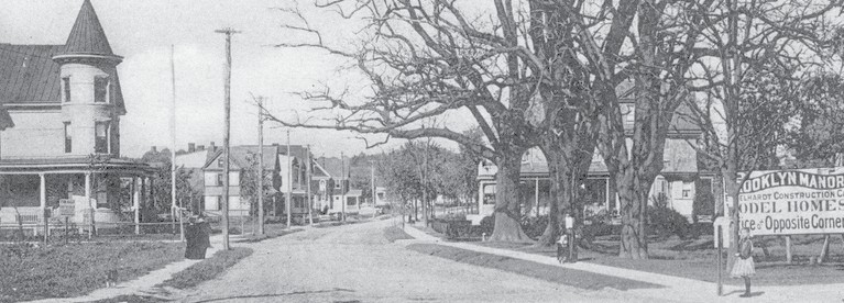
Naturally, confusion resulted from having two roads with the same name only a few miles apart, and by 1898—the same year Queens became part of New York City—the former Trotting Course Lane and South Meadow Road took on the title Woodhaven Avenue, adopting the name of the community through which it runs.
The city later realigned a portion of Woodhaven Boulevard through Glendale, straightening it to make it safer. A portion of the old road remained, and was given the old Trotting Course Lane title.
Segments of Trotting Course Lane remain today in Glendale and Rego Park, and at the entrance to the Forest Park Crescents co-op building off Union Turnpike.
Crossing the bay
Meanwhile, in 1918, the city decided to build a road across Jamaica Bay to Rockaway Beach, then connect this new road to Woodhaven Boulevard and Liberty Avenue in Ozone Park. The work started on the road, which was to be 100 feet wide, in October 1921.
Because of the nature of the terrain, it was necessary to drive numerous steel and reinforced concrete piles on each side of the proposed road as a bulkhead. Then, using suction dredges, sand was scooped up from the bay and poured in between the bulkheads to form the road.
The project also included new water mains laid from the Ridgewood Reservoir—then used as part of the city’s water supply—to the peninsula.
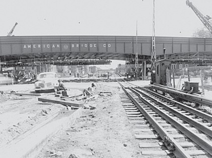
It was also necessary to build two large bridges across sections of the bay—the North Channel Bridge, a fixed span linking Howard Beach and Broad Channel; and the Cross Bay Bridge, a four-lane drawbridge between Broad Channel and the Rockaway Peninsula.
The total cost of this project, when it was completed in 1925, was just under $7 million. It opened on Oct. 26 of that year and was named Cross Bay Boulevard.
As Queens developed in the early 20th century and more residents moved in, the city also worked to improve the entire stretch of Woodhaven Avenue— and subsequently changed the name to Woodhaven Boulevard.
As a separate project, but part of an overall construction plan, the city widened Woodhaven Boulevard from 100 to 150 feet from Queens Boulevard south to the new road at a cost of $1.5 million.
The project led to a bit of a rebellion among Glendale and Woodhaven residents, who believed that it benefitted people who lived in Manhattan and not local residents.
In all, the combined Cross Bay and Woodhaven boulevards shortened the distance between Brooklyn and Manhattan and Rockaway Beach by about 10 miles.
The expressway that wasn’t
The boulevards quickly became the main north-south artery through western and southern Queens, and in 1941, the New York City Planning Department proposed developing an express highway—a forerunner to the modern expressway—along the length of the route from Queens Boulevard to the Rockaway Peninsula. After the U.S. entered World War II, those plans were scrapped.
Following the war, Queens did get a north-to-south expressway: the Van Wyck and Whitestone expressways, running from the Bronx-Whitestone Bridge to what would later become Kennedy Airport.
Woodhaven and Cross Bay boulevards were spared a project that would have displaced thousands of residents and changed the very face of the communities through which the boulevards run.
Drivers through the years have relied on the roads to reach not just the beaches of Rockaway but also a host of other historic spots, including Forest Park; the longdefunct St. Anthony’s Hospital in Woodhaven, once a pioneer in cardiovascular and pulmonary medicine; and Aqueduct Racetrack, located about a halfmile east of the boulevards off Rockaway Boulevard.
Further improvements
As time when on, the roads were renovated periodically. A Works Progress Administration project during the Great Depression resulted in the reconfiguration and straightening of the boulevard between Park Lane South and Atlantic Avenue. Overpasses were also constructed above the Long Island Rail Road’s Montauk branch in Glendale and Atlantic Avenue, below which the LIRR’s Atlantic Terminal line runs.
In 1970, the drawbridge connecting Broad Channel and the Rockaway Peninsula was replaced with the Cross Bay Veterans Memorial Bridge, a sixlane, fixed bridge operated by the Triborough Bridge and Tunnel Authority (later the MTA Bridges and Tunnels Division). While the new bridge an upgrade, it came with toll booths that prove controversial to this day.
The Cross Bay Bridge remains the only intra-borough toll crossing in the city, meaning that drivers coming from one Queens neighborhood have to pay to travel to another Queens neighborhood. For years, Rockaway and Broad Channel residents were exempt from the toll, but in 2010, the MTA— facing a financial crisis—began charging those drivers, though the rate was discounted.
Meanwhile, on the north side of the Broad Channel, the North Channel Bridge fell into disrepair during the 1980s to such an extent that a standard renovation wouldn’t be enough to save it. The city replaced the span in 1988 with the Joseph P. Addabbo Bridge, named for the late congressman who represented the area and also the father of current State Sen. Joseph P. Addabbo Jr.
If you have any remembrances or old photographs of Our Neighborhood that you would like to share with our readers, please write to the Old Timer, c/o Times Newsweekly, P.O. Box 863299, Ridgewood, NY 11386, or send an email to neighborhood@timesnewsweekly.com. Any print photographs mailed to us will be carefully returned to you.