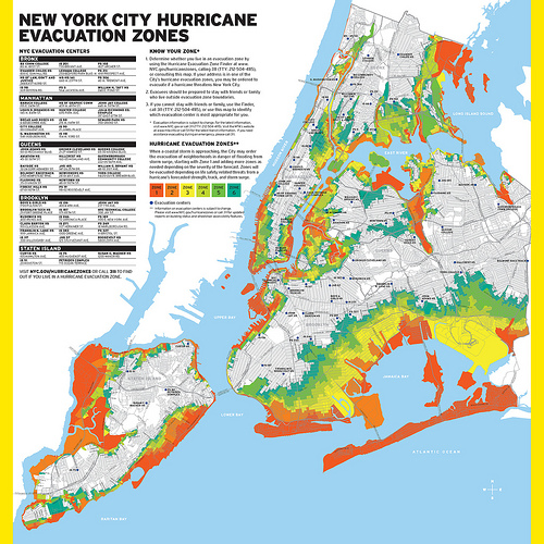
The city has released an updated hurricane evacuation zone map that replaces Zones A, B and C with zones numbered one to six, and includes an additional 600,000 New Yorkers that were not part of the former evacuation areas.
It also contains an extra 26 New York City Housing Authority developments, four hospitals and nine nursing homes.
Last month the city announced it would be revising the zones based on its Hurricane Sandy After-Action report, which analyzed the city’s response to the storm.
The increased number zones will allow for “more flexibility in targeting areas to evacuate in advance of a predicted storm,” according to the city.
“Over the past six months we have made remarkable strides in the city’s recovery from Hurricane Sandy, and as part of our review of the Administration’s efforts before and after the storm, we have updated and expanded the hurricane evacuation zones that are part of the city’s comprehensive Coastal Storm Plan,” Deputy Mayor for Operations Cas Holloway. “The new zones incorporate the best-available data and will help the city to more effectively communicate to those most at risk depending on the characteristics of a particular storm.”
One notable change on the new map is to Howard Beach.
Most of the neighborhood, which sat in Zone B, is now evacuation Zone 1.
During Sandy, several areas outside of Zone A saw significant flooding. Residents there felt they should have been included in mandatory pre-storm evacuations.
Residents can visit maps.nyc.gov/hurricane or call 311 to find out if their homes or businesses fall within the boundaries of a new city hurricane evacuation zones.

RECOMMENDED STORIES
- Bloomberg presents plan to protect city against climate change
- MTA to shut down G, R trains for Sandy-related repairs
- Queens pols hopeful about Build it Back Sandy recovery program