More Open Streets, the city’s program to limit vehicular traffic and provide more space for pedestrians and cyclists in designated streets, are coming to Astoria, Jackson Heights, Bayside, Ridgewood, Jamaica and Far Rockaway.
On Wednesday, Mayor Bill de Blasio announced the city will be adding another 23 miles to the program, bringing the citywide total to 67 miles. The goal is to reach 100 miles of Open Streets, a plan the mayor announced after the City Council proposed 75 miles of car-free streets during the COVID-19 pandemic so pedestrians have more space for social distancing.
The new slate of Open Streets will be located primarily in neighborhoods hit hardest by the health crisis, according to the mayor’s office, and will include nine additional miles of temporary protected bike lanes throughout the city. Almost four miles of protected bike lanes will be established on Broadway/Northern Boulevard, from 34th Avenue to Queensboro Plaza.
The temporary bike lanes will be phased in throughout the summer using markings, barrels, signage, and other barriers, to implement both permanent and temporary projects along with critical connectors from already established protected lanes.
The Open Streets program is facilitated by each neighborhood’s local community organizations, Business Improvement Districts, police precincts or other city partners. The following are the new Open Streets coming to Queens:
Astoria
- Newtown Avenue, from 30th Avenue to 31st Street. On Fridays, Saturdays and Sundays from 10 a.m. to 8 p.m. Managed by Central Astoria LDC. Mileage: 0.15.
- Ralph DeMarco Park’s adjacent roads: Shore Boulevard, from Ditmars Boulevard to 20th Avenue (Mileage: 0.33); and Ditmars Boulevard, from 19th Street to Shore Boulevard (Mileage: 0.12).
Jackson Heights
- 37th Avenue, from 75th Street to 80th Street. On Sundays from 10 a.m. to 4 p.m. Managed by Thai Community USA. Mileage: 0.24.
Woodside
- 60th Street, from Queens Blvd to 43rd Avenue. Managed by local precinct. Mileage: 0.07.
Ozone Park
- 77th Street, from Atlantic Avenue to 101st Street. Managed by local precinct. Mileage: 0.29.
Ridgewood
- Onderdonk Avenue, from Starr Street to DeKalb Avenue. Managed by local precinct. Mileage: 0.20.
Jamaica Hills
- 165th Street, from Chapin Parkway to 85th Avenue. Managed by local precinct. Mileage: 0.09.
Far Rockaway
- Reads Lane, from Empire Avenue to Jarvis Avenue. Only on Saturdays from 8 a.m. to 8 p.m. Managed by Jewish Community Council of the Rockaway Peninsula. Mileage: 0.52.
- Beach 12th Street, from Central Avenue to Dinsmore Avenue. Only on Saturdays from 8 a.m. to 8 p.m. Managed by Jewish Community Council of the Rockaway Peninsula. Mileage: 0.25.
- Rockaway Freeway, from Ocean Crest Blvd to Regina Ave. Managed by local precinct. Mileage: 0.27.
Bayside (park adjacent road)
- Crocheron Park’s 35th Avenue, from Corbett Road to Dead End. Mileage: 0.28.
“As the school year ends and a hot, challenging summer begins, New Yorkers will need more options to play outside,” said de Blasio. “New York City now offers more car-free street space than any other city in the country, and we’re proud to build on that progress in all five boroughs.”
In April, the mayor and Council Speaker Corey Johnson announced that 40 miles of streets citywide would be opened by the end of May to allow greater social distancing. The city exceeded its 40-mile target last month.
No through traffic is permitted in the Open Streets, with remaining vehicle traffic limited to local deliveries, pick-ups/drop-offs, necessary city service, utility, and emergency vehicles only — those drivers are alerted to be hyper-vigilant and to drive at 5 mph along these routes.
Google has already added the previous 40-plus miles of Open Streets into Google Maps, which allows drivers using online navigation to steer clear of these streets. The new Open Streets will also be added to Google Maps in the coming days.

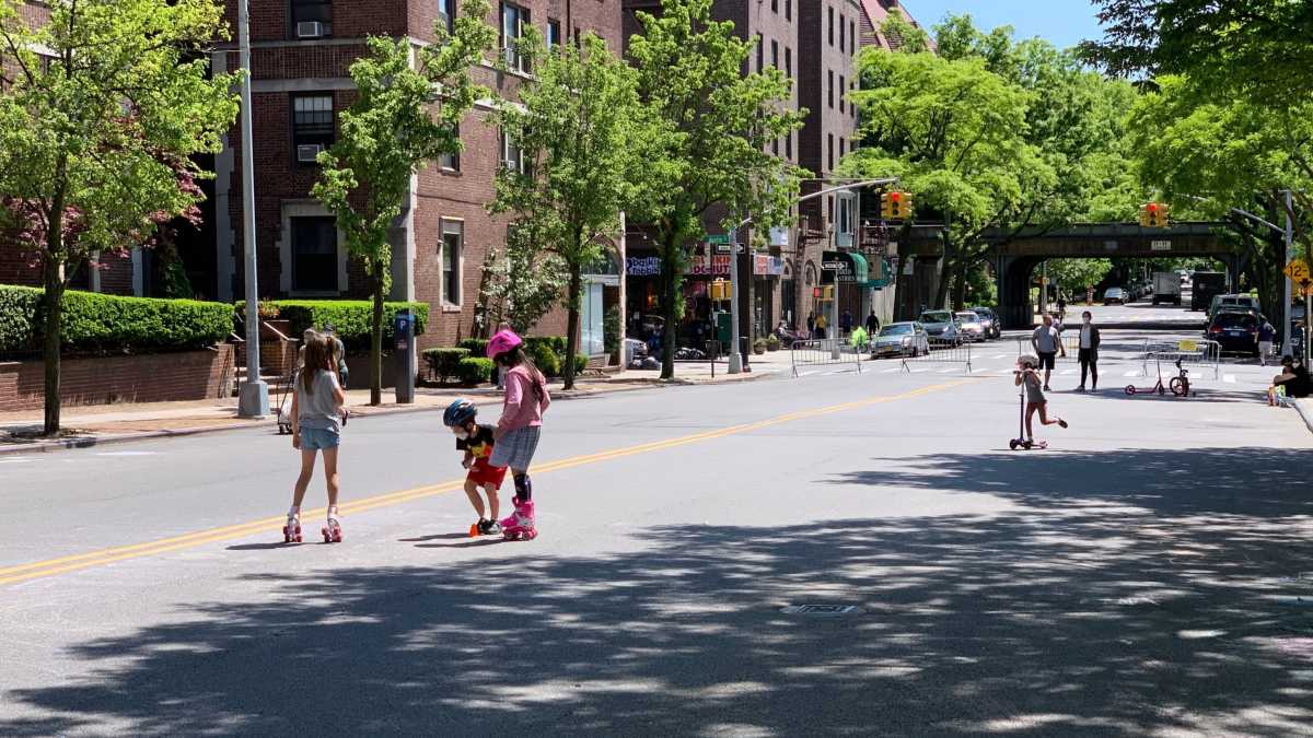
Jackson Heights’ 34th Avenue, among one of the city’s first Open Streets in Queens, has been a huge success. Residents have praised the additional space that allows them to be outside while maintaining a safe distance from neighbors.
State Senator Jessica Ramos said her and her constituents are grateful the program is expanding in her district.
“The Open Streets Program has been a huge success for our residents in Jackson Heights, allowing neighbors of all ages to walk, bike, play or just sit outside for some fresh air with plenty of room to social distance and without worries of car traffic,” Ramos stated. “We’re grateful to have this program expand so that more New Yorkers can enjoy being outside as our city re-opens.”
Department of Transportation Commissioner Polly Trottenberg is also enthusiastic about the new additions.
“With summer now in full swing, and the city slowly reopening, we’re excited to bring new Open Streets to more communities, from the North Shore of Staten Island to Far Rockaway in Queens, along with new protected bike connections to Central Park and the Queensboro Bridge,” said Trottenberg. “Thanks to the hard work of Mayor de Blasio, our sister agencies, BIDs and other community groups, Open Streets continues to grow, helping more New Yorkers who’ve been cooped up for so long get out and keep moving while maintaining social distancing.”
Organizations wishing to have other New York City streets considered for the Open Streets program should reach out to fill out an online survey. For more information, visit nyc.gov/openstreets.