Of all the myriad advents of the Internet age, one of the best has to be the ability to see aerial images of just about anywhere you’d like — including your own neighborhood. And it’s free, as long as you have a computer or smartphone.
Decades ago, this was nearly impossible without adequate resources. You had to commission a pilot to fly over an area with a camera on board. The Space Age allowed nations to launch camera-equipped satellites into orbit, providing our planet with an unprecedented view of itself — but the general public finally got access to such images in June 2001 with the advent of Google Earth.
Today, you can get a bird’s-eye view of your neighborhood taken just a few months ago. You can see your community as it stands today. But did you ever wonder how your community appeared eight decades ago?
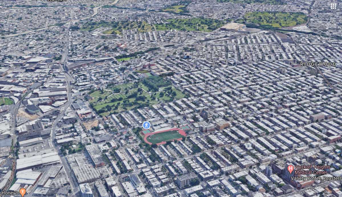
The image above is a 3D Google Earth snapshot that’s similar to the angle of this picture, taken in 1940. The NYC Municipal Archives provided it to us.

It’s truly incredible to see how dramatically the area has changed over the course of eight decades. If you don’t recognize all the points in the 1940 aerial shot, we’ll be happy to point out some of the more prominent locations to you.
Here’s an image of the same map with 13 points delineated in red, and we’ll follow that with a picture-by-picture guide of the points of interest.

1. Flushing Avenue

Long before factories lined it, much of the Ridgewood section of Flushing Avenue abutted some of the largest farms in the neighborhood. Farms once owned by the Onderdonk and Wyckoff families extended over much of the area south of Flushing Avenue and would rapidly be developed in the 20th century into new businesses and residences.
2. Onderdonk House

Standing at the corner of Flushing and Onderdonk Avenues, the Onderdonk House remains the lone reminder of Ridgewood’s colonial and agricultural past. The house dates back to the period when the Dutch controlled New York. It today serves as the home base of the Greater Ridgewood Historical Society, and educates generations of Ridgewood residents on the neighborhood’s proud history.
3. Bohack Square

No one calls the corner of Flushing and Metropolitan Avenues “Bohack Square” anymore, but decades ago, this was the hub of one of New York’s largest supermarket chains. The intersection housed Bohack’s corporate headquarters and warehouses. Reminders of the chain’s past remains visible to visitors today passing through the area.
4. Linden Hill Cemetery

Traveling east on Metropolitan Avenue, the gates to the Linden Hill Cemetery stand at the intersection of Grandview Avenue. One of the largest and oldest burial grounds in the community, Linden Hill serves as the final resting place for generations of Ridgewood residents.
5. Grover Cleveland High School

Located further south and east at 2120 Himrod St., Grover Cleveland High School is the neighborhood’s largest public high school. The school opened in 1931, and its first principal, Charles Tonsor, led the school for the next several decades. The nearby Tonsor Street is named for him.
6. The “car barns”

A few blocks away, at the corner of Stanhope Street and Seneca Avenue, stood “the car barns,” the storage depot for the many trolleys serving the Greater Ridgewood area. The barns were prominent in the 1940 aerial image, but they faded into history just decades later. The barns were redeveloped as the Grover Cleveland High School athletic fields.
7. St. Aloysius Church
![]()
The twin spires of St. Aloysius Church have stood over the corner of Onderdonk Avenue and Stockholm Street for decades, inviting the faithful to come and pray. The house of worship is across the street from the historic, Belgian-brick lined block of Stockholm Street — Ridgewood’s first landmark district.
8. Our Lady of the Miraculous Medal Church

Further to the east stands Our Lady of the Miraculous Medal Church. The Catholic house of worship has provided services for decades at the corner of 60th Place and Bleecker Street.
9. LIRR Lower Montauk Branch

The Lower Montauk branch of the Long Island Rail Road is quite visible as it cuts a swath through the community, serving as the border between Ridgewood/Glendale and Middle Village. The last commuter train ran on this branch back in 1997; today, it remains in service to freight rail operations.
10. End of the M Line

Originally built as an extension of the Myrtle Avenue El to Downtown Brooklyn, the 10th site on our list is the current site of the Middle Village-Metropolitan Avenue subway station. These days, of course, it’s the last stop (or first stop, depending on your perspective) on the M train, which runs through Bushwick, Williamsburg, Manhattan and northern/central Queens.
11. Fresh Pond Crematory

Sitting at the top of “Crematory Hill” overlooking Maspeth and Middle Village since the early 1920s, the Fresh Pond Crematory has provided services to the dearly departed for more than a century. The Romanesque structure also houses the ashes of generations of prominent individuals who lived in New York.
12. Eliot Avenue

Developed just before the start of the 1939-40 World’s Fair, Eliot Avenue quickly became one of the neighborhood’s most important roadways. It also opened up new farm land for the development of new homes across Maspeth and Middle Village, including the Juniper Park homes near Juniper Valley Park.
13. Elmhurst Gas Tanks

Finally, the twin Elmhurst Gas Tanks not only provided fuel for local residents but, in later years, became a landmark on traffic reports about volume on the Long Island Expressway, which was built in the 1950s. The tanks finally came down in the late 1990s, and the site was redeveloped as a public park.
* * *
If you have any remembrances or old photographs of “Our Neighborhood: The Way It Was” that you would like to share with our readers, please write to the Old Timer, c/o Ridgewood Times, 38-15 Bell Blvd., Bayside, NY 11361, or send an email to editorial@ridgewoodtimes.com. Any print photographs mailed to us will be carefully returned to you upon request.